 | ||||||||
|
Selasa, 06 November 2007


Orchid exhibit offers colorful experience
Orchid exhibit offers colorful experience
In commemoration of its 50th anniversary, the Indonesian Orchid Association is holding a 10-day exhibition at Taman Mini Indonesia Indah, East Jakarta.
Through April 22, visitors can enjoy a stunning array of orchid varieties, including local varieties such as Dendrobium fatahillah and Coelogyne celebensis, at the amusement park's Purna Bhakti Pertiwi Museum.
Officially opened last Saturday, the exhibition is a meeting place for breeders, collectors and hobbyists.
"I hope that our 2007 Orchid Festival will bring together everyone involved in orchids," association chairwoman Mufidah Jusuf Kalla told Antara during last Saturday's exhibition opening.
Exhibition coordinator Rossi Anton Apriyantono said the festival would showcase Indonesia's latest orchid hybrids, allowing visitors to get in direct contact with producers.
According to Rossi, despite Indonesia's richness of orchid varieties, the country still lags behind neighboring Malaysia, Singapore and Thailand when it comes to gaining a share of the global orchid market.
"Singapore will host the World Orchid Conference for the second time in 2011, while Indonesia has never once been appointed to host the event," Rossi said.
Indonesia's share of the global orchid market stands at about US$1.5 million annually, just a fraction of the total yearly orchid trade of $250 million, Agricultural Minister Anton Apriyantono said.
Illega logging is seen as a major threat to the variety of orchids in Indonesia, as more and more species are lost.
Although collectors and hobbyists seem to be in the forefront of orchid conservation, they also contribute to the problem of the lack of mass cultivation of rare orchid species, Anton said.
"Some of them want their rare flowers to remain rare and expensive," he said.
Most of Indonesia's more valuable species, like the Paphiopedilum javanicum, Phalaenopsis javanica and Phalaenopsis gigantia, now often end up in the hands of collectors in Taiwan, Thailand and European countries.
To support Indonesian orchid exports, the Agricultural Ministry is planning to scrap quarantine fees on agricultural products.
Source: Thejakartapost.com
World`s biggest bryophyte park in Cibodas dedicated
World`s biggest bryophyte park in Cibodas dedicated
The Cibodas bryophyte park, part of the Cibodas Botanical Garden (KRC ) in Pacet subdistrict, Cianjur regency, West Java, and believed to be the only outdoor moss park in the world, was dedicated by Mrs Umar Anggara Jenie, wife of the Head of the Indonesian Council of Sciences (LIPI ).
Head of the KRC Vegetation Conservation Institute Holif Immamudin said on the sidelines of the dedication of the 1,500-m2 bryophyte park, which will be expanded to 2,500 m2, located between Mt Gede and Mt Pangrango, that everything in the KRC is the biggest in the world.
"With its biggest outdoor moss park in the world, Indonesia will be known as a country which is serious in plant conservation," he said.
Actually, Germany and Singapore also have a moss park, but indoor, and having only seven species, and the one in Japan has only 10 species.
He said that Indonesia is rich in biodiversity, as all the 3,000 different moss species in the world are also found in Indonesia, and 250 of them are found in the Cibodas Botanical Garden, he said.
But unfortunately, he said, the condition of one of Indonesia`s biodiversity lacked attention of the appropriate authorities, whereas moss has an important role to play in the life of human beings.
Some of the benefits of bryophytes he said moss maintains humidity of the air and land porosity, and is a water binder.
And moss of the Usnea species also has a medical potential, while a moss of the Spaghnum species is known to replace cotton, and could heal skin and eye diseases, and serve as a means for the growth of orchids. Moss of the marchantia species is known to heal hepatitis.
But all these moss species must first be clinically tested before using them as a medical drug.
The moss park is designed on the basis of a cultivated landscape.
Its strategic location makes it very easy for visitors to see it, because the moss park is only 600 meters away from the KRC entrance, and can also be reached through the Rhododendron Park and an asphalted road to Curug in Cibogo.
In the meantime, Bian Tan, program coordinator for Southeast Asia told the press that the moss species in Indonesia are the most complete in the world.
Besides, he added, as it is located in a tropical region surrounded by mountains, the air around it remains humid, unlike those in other countries like Germany, Singapore and Japan, which are located indoor.
The the bryophyte park was dedicated also on the occasion of the 154th anniversary of the KRC.
Spiritual Tourism for Bali
2007
Spiritual Tourism for Bali

According to the Minister, "a source for tourism in Bali for the future is spiritual tourism because of the potentials and possibilities offered in the cities and regions in Bali."
Speaking before a conference on "Major Trends – Opportunities and Investments in Tourism," Wacik said the main market sources for spiritual tourism are from Japan, Europe and the United States. "Tourist coming from these countries have become bored with crowded tourist attractions and are now seeking 'quieter' tourism, such as places for mediation and reflections upon their Creator," he explained.
The Minister said that all locations in Bali have potential for spiritual tourism together with other destinations in Indonesia, such as Tanah Toraja in Sulawesi and Central Java. Wacik emphasized that in addition to the physical location for this form of tourism, it is also essential to have staff trained in meditative practice and yoga.
Commenting separately, Bali's Chief of Tourism, Drs. I Gede Nurjaya, said that the Balinese have a close connection with nature and an all pervading sense of spirituality. The leading government official in charge of Bali's tourism said that the Balinese see nature in a religious context and have a wide range of ritual practice honoring nature. Because of this, said Nurjaya, Bali is the proper choice of location for the development of spiritual tourism.
Kanha National Park
Kanha National Park
 This park is situated in the heart of Sal forests of the Central high lands of Mandla and Balaghat districts. It covers 940sq.km in area. It was set up in 1995. The nearest town Mandla is 65 km, Jabalpur which is160 km from the park is both rail head as well as air port; Nagpur is 270 km from the park.
The park has sparsely wooded grassy plateau, sprawling slopes with lush green, trees and bamboos. There are also plenty of smaller plants, creepers and mushrooms. The landscape, rich in vegetation presents a spellbinding view and is eminently suitable for providing shelter to a variety of mammals and birds.
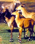
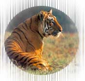
This area was initially made a sanctuary in 1955 to protect the magnificent barasingha-swamp deer from extinction. The fauna of the park consists of barasingha, cheetal sambar, black duck, barking deer, gaur, hog deer, chausingha, bison, boar, tiger, leopard, hyena and wild dog. It is also the tiger reserve under project tiger. The number of tigers has doubled and barasingha have crossed the 450 mark. There are nearly two hundred bird species such as storks, teals, pintails, egrets, peafowl, partridges, doves, pigeons, cuckoos, eagles, kites, etc.
February to June are the best months for visiting the park.
Bandharvgarh National Park
Situated in Shahdol and Jabalpur districts, the park with an area of 437 km was set up in 1968. The nearest town from the park is Umaria, 35 km away. This town is also the nearest rail head. The nearest airport is at Jabalpur at a distance of 160km.
The park contains moist deciduous forests with Sal and other trees with large stretches of grass lands with bamboo groves. The fauna consists of tiger, panther, leopard, gaur, chausingha, nilgai, chinkara, sloth bear, bear, wild boar, and a variety of birds.
March to June are the ideal months for visiting the park.
Madhav National Park
Set up in the year1959, the park is spread over 337 sq km in the district of Shivpuri. The nearest town is Shivpuri 6kms away. The rail head is Jhansi 100 km from the park and the nearest airport is Gwalior at a distance of 116 km.
The park consist of dry forests of anogeisus lotifolia. The fauna found are tiger, panther, leopard, spotted deer, black buck, sambar, hyena, chausingha, langur, nilai, crocodile and python. The spoonbills, waterside birds and demoiselle cranes. The park has several rest houses and motel. April - June and October - February are suitable months for visiting the park.
Panna National Park
Spread over an area of 543sq.km in the districts of Panna and Chhatarpur, this park was established in 1981. The nearest town from the park is Panna 20 km away and the rail head is at Satna which is at a distance of 95 km. The nearest airport is Khajuraho 20 km away.
The forests of the park are tropical dry deciduous. The fauna found are leopard, panther, tiger, chinkara, sloth bear, wolf, wild pig, nilgai, gharial ,mugger, crocodile, and peafowl.
The best month for visiting the park are November to April.
Satpura National Park
The park is located in the district of Hoshangabad covering an area of 502sq.km. The nearest town is Pamchamarhi. The nearest railhead is Piparia at a distance of 55 km and the nearest airport is Bhopal at a distance of 210 km.
The fauna comprise leopard, tiger, barking deer, Sambar, nilgai and bison. Hornbill and peafowl are the common birds.
The best month for visiting the park are January to June.
Van Vihar National Park
This park was established in 1979 in the district of Bhopal with an area of 4.45sq.km. The state capital is only 3km away from the park. Bhopal airport and railhead are at a distance of 12km and 7km respectively from the park.
The fauna of the park comprise leopard, tiger, ratal, bear, Sambhar, black buck etc.
July to September are the best months for visiting the park.
Fossil National Park
Established in the year1983. The fossil National park is located in the district of Mandala in an area of 0.27sq.km. The nearest town from the park is Shahpura at a distance of 13km. The nearest railhead and airport are at Jabalpur, 87km from the park. The park contains botanical fossils.
The best period for visiting the fossil National park is November to May.
This park was established in 1979 in the district of Seoni in an area of 293sq.km. Seoni, the nearest town from the park is 50km from here, Nagpur serves as the airport and the railhead for visiting the park which is at a distance of 90km from it.
The park contains dry mixed deciduous forest. The fauna of the park comprises tiger, leopard, sloth bear, sambar, gaur, chital, barking deer four horned antelope wild dog and wild boar.
March to June is the best period for visiting the park.
Ranthambore National park
Ranthambore National park
 Set up in 1955, Ranthambore National park is situated in the district of Sawai-Madhopur, at the function of Aravalis and Vindhyas covering an area of 392sq.km. The nearest town and the railhead from the park is Sawaimadhopur. The nearest airport is Jaipur at a distance of 132km.
The land consists both of steep slopes and gently rolling plateau on the hill top. The forests are dry deciduous dominated by dhok trees interspersed with grasslands. There are scattered pools to provide water to the wild animals. The well forested park harbours diverse fauna which include tiger, leopard, wild boar, caracal, sloth bear, ratel, hyena, civet, jungle cat, sambar, chinkara, nilgai, four-horned antelope, python, cobra, crocodile, partridge, green pigeon, red spur fowl, peafowl, parakeet, teal etc.
The best period for visiting the park is October to April.
Sariska National park
The park was set up in 1982 in the district of Alwar covering an area of 274sq.km. The nearest town and the rail head is Alwar at a distance of 36 km from the park, Jaipur is the nearest airport at a distance of 110 km.
The tract of the park is mainly hilly with two plateaus. The forests are dominated by dhok.
The fauna of the park comprise tiger, leopard, panther, wild boar, hyena, jungle cat, civet, four horned antelope, sambar, cheetah, ratel, caracal, chinkara, nilagi, partridges, green pigeon and pea fowl.
The park can be visited round the year except in July, August, and September. It has rest houses.
Keoldeo National park
The park set up in1981 in Bharatpur district, 2 km away from Bharatpur town, covers an area of 29 km. The nearest rail head is Bharatpur at a distance of 8 km. The nearest airport is Agra 55km from the park.
The park has tropical dry deciduous forest type. Some 282 species of trees, shrubs, climbers, grasses and herbs are found here. Out of these ninety one species of plants are acquatic.
The park often referred to as paradise for birds is famous of the variety of indigenous and migra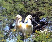 tory birds, both aquatic and non aquatic. The fauna of the park are Siberian crane cormorant, stork, spoonbill, quail, coot, heron, teal, tern, sambar, cheetah, black buck, wild boar, civet etc. The Siberian crane which breed in Siberia usually visit this park during November- December after covering a distance of 4,000km and go back in March. This species is critically endangered. The number of those cranes visiting the park has dwindled sharply from 100 in 1976 to just 5 in 1993.
The best months for visiting the park are from September to April. The park has rest houses. All areas for watching wild life are within walking distance.
Name of the National Park | Nearest Town, | Best Period for visiting | Accommodation | Contact address |
| Keoldeo Ghana | Nearest Town - Bharatpur - 2km | Throughout the year | Bharatpur Forest Lodge (ITDC) 2.5km inside the sanctuary, Shanti Kutir Rest House, Saras, outside the park, Tented Camp near park entrance. | Dy Chief Wildlife Warden, Keoldeo National Park, Bharatpur. |
| Ranthambore | Nearest Town - Sawai Madhopur - 14km. | October to April | Jogi Mahal (within the park), Outside: Sawai Madhopur Lodge(Taj), Tiger Moon Resort, Ankur Resorts, Ranthambore Road. | Field Director, Ranthambore National Park, Sawai Madhopur |
| Sariska | Nearest Town - Alwar - 36km. | November to June | Kushalgarh Palace, 6 Km before Sariska Palace | Field Director, Sariska Tiger Project. |
Namdapha National Park
Namdapha National Park
Nearest town: Margherita ( Assam) 63 km
Best time to visit: October to April
Main attraction: Snow leopard nearly 163 Km from Dibrugarh (Assam)
 Namdapha National Park is located in the Changlang District of Arunachal Pradesh on the India Burmese border a few km from the entry point, Miau. It was designated as a National Park in 1983 under the Wildlife (Protection) Act. The same year, it was also declared as tiger reserve under Project Tiger. With a total area of 1985 sq kms, this is the largest national park in the north-east and one of the larger protected areas in the country. In fact, this was among the earliest national parks established in the seven states of north-east India.
The park watered by the Noa- Dehing and the Namdapha rivers, is largely inaccessible, with diverse habitats of flora and fauna. The vegetation ranges from the wet evergreen tropical and sub-tropical forests to temperate and alpine forests. A variety of wild tree species and crop plants including banana, mango, citrus and medicinal and ornamental plants including wild orchids are found here. The inaccessibility has helped the forests to retain its pristine ness.
The fauna of the park comprises elephant, tiger, leopard, snow leopard, clouded leopard, golden cat, wild dog, endangered Hoolock gibbon, Namdapha Flying Squirrel, wild buffalo, guar, hog deer, sloth bear, bison, Himalayan Tahr, Bharal, python, King cobra, , the wild goats; takin peculiar to the Patkoi range, Serow and Goral etc. The park is rich in bird life. The important birds are Indian Horn bill, the state bird of Arunachal, white winged wood duck, cheer pheasants etc.
The park is unique in its altitude, which varies around 200 metres (nearly sea level) in the valleys to more than 4,500 metres of snow covered mountain peaks. Perhaps no other national park in the world can boast of such phenomenal altitudinal variation. The park is also ideal for trekking and hiking. From Miau the entry point, a forest road stretching over 28-km gives access to the protected area up to a place called Deban where accommodation is available. Beyond this there is no road and one has to go on foot. It is a challenging trek through dense forests and steep hill ranges with rivers flowing in between and the varying climatic conditions from tropical to cold and temperate conditions..
Where to stay
Accommodation is available at the Government Tourist Lodge, Miao; Rest House at Namchik and at the Forest Inspection Bungalow surrounded by evergreen forests overlooking river Noa-dihing. For reservation at the forest inspection Bungalow, Deban contact
Deputy Commissioner, Tawang, Phone: 037824 - 22221 (O) 22222 (R)
How to get there
Air: The nearest airport is Dibrugarh, Assam (140 km).
Rail: The nearest rail-head is Ledo (56 km) and the nearest station is Margherita in Assam. Local train connects Margherita to Tinisukia which is connected with major cities of India.
Road: Good motorable roads connect Miao (entry point of the park) to Dibrugarh (140 kms), Tezu (182 kms), Sibsagar (199 kms), Guwahati (561 kms) etc. Miao can be reached by Jeep/Gypsy from Margherita (Assam)
Contacts
-
Field Director,
Project Tiger,
P.O. Miao, Dist. Tirap,
Arunachal Pradesh. -
Dy.Conservator of Forests,
Namdapha National Park,
PO, MIAO, District Tirap. -
Assistant Director (Tourism),
O/o the D.I.P.R.,
Govt. of Arunachal Pradesh,
Naharlagun, Tel: (03781) 44115. -
Govt. of India Tourist Office,
Sector- C, Naharlagun- 791 110.
Phone: (03781) 44328.